Wednesday, February 24, 2021

MYANMAR


MYANMAR


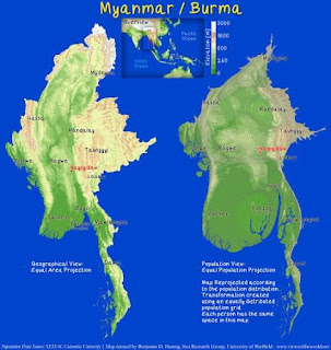
           Myanmar (also known as Burma) is the northwesternmost country of mainland Southeast Asia. It lies along the Indian and Eurasian Plates, to the southeast of the Himalayas. To its west is the Bay of Bengal and to its south is the Andaman Sea. It is strategically located near major Indian Ocean shipping lanes. The neighboring countries are China, India, Bangladesh, Thailand and Laos.

PHILIPPINES


PHILIPPINES


            The Philippines is an archipelago, or string of over 7,100 islands, in southeastern Asia between the South China Sea and the Pacific Ocean. The two largest islands, Luzon and Mindanao, make up for two-thirds of the total land area. Only about one third of the islands are inhabited.

BRUNEI


BRUNEI 


        Brunei is a country in Southeast Asia, bordering the South China Sea and East Malaysia. Its geographical coordinates are 4°30′N 114°40′E. The country is small with a total size of 5,765 km2 (2,226 sq mi). It is similar in size to the UK's Norfolk and slightly smaller than the US state of Delaware. It is close to vital sea lanes through the South China Sea linking the Indian and Pacific Oceans. The country has two parts physically separated by Malaysia, making it almost an enclave within Malaysia.
Brunei shares a 266 km (165 mi) border with Malaysia and has a 161 km (100 mi) coastline.


VIETNAM


VIETNAM 


             Vietnam is a country of tropical lowlands, hills, and densely forested highlands, with level land covering no more than 20 percent of the area. The country is divided into the highlands and the Red River Delta in the north; and the Giai Truong Son (Central mountains, or the Chaîne Annamitique, sometimes referred to simply as the Chaine), the coastal lowlands, and the Mekong River Delta in the south.


CAMBODIA


CAMBODIA 


        Cambodia's main geographical features are the low lying Central Plain that includes the Tonlé Sap basin, the lower Mekong River flood-plains and the Bassac River plain surrounded by mountain ranges to the north, east, in the south-west and south. The central lowlands extend into Vietnam to the south-east. The south and south-west of the country constitute a 443 km (275 mi) long coast at the Gulf of Thailand, characterized by sizable mangrove marshes, peninsulas, sandy beaches and headlands and bays. Cambodia's territorial waters account for over 50 islands. The highest peak is Phnom Aural, sitting 1,810 metres (5,938 ft) above sea level. 
        The landmass is bisected by the Mekong river, which at 486 km (302 mi) is the longest river in Cambodia. After extensive rapids, turbulent sections and cataracts in Laos, the river enters the country at Stung Treng province, is predominantly calm and navigable during the entire year as it widens considerably in the lowlands. The Mekong's waters disperse into the surrounding wetlands of central Cambodia and strongly affect the seasonal nature of the Tonlé Sap lake. 

Northernmost point: Ta Veaeng District, Rattanakiri Province 
Southernmost point: Koh Poulo Wai, Kampot Province 
Easternmost point: Ou Ya Dav District, Rattanakiri Province 
Westernmost point: Malai District , Banteay Meanchey Province


INDONESIA


                                                     INDONESIA


           Indonesia is an archipelagic coluntry located in Southeast Asia, lying between the Indian Ocean and the Pacific Ocean. It is located in a strategic location astride or along major sea lanes connecting East AsiaSouth Asia and Oceania. Indonesia is the largest archipelago in the world. 

            Indonesia's various regional cultures have been shaped—although not specifically determined—by centuries of complex interactions with its physical environment.


SINGAPORE


 SINGAPORE 


              Singapore's main territory is a diamond-shaped island, although its territory includes surrounding smaller islands. The farthest outlying island is Pedra Branca. Of Singapore's dozens of smaller islands, Jurong IslandPulau TekongPulau Ubin and Sentosa are the larger ones. Most of Singapore is no more than 15 metres above sea level.

            The highest point of Singapore is Bukit Timah Hill, with a height from ground of 165 m (538 ft) and made up of igneous rockgranite. Hills and valleys of sedimentary rock dominate the northwest, while the eastern region consists of sandy and flatter land. Singapore has no natural lakes, but reservoirs and water catchment areas have be en constructed to store fresh water for Singapore's water supply.

            Singapore has reclaimed land with earth obtained from its own hills, the seabed, and neighboring countries. As a result, Singapore's land area has grown from 581.5 km² in the 1960s to 725.7 km² today, and will increase slightly more due to construction of sea polder and barrage to deal with the ever raising sea level.